A severe heatwave and a potential high fire danger risk will drive temperatures into the high 30s this week. Photo: Michael Weaver.
The ACT and the surrounding region can expect the first total fire bans of the bushfire season within a week as a significant mass of hot air is forecast to push temperatures close to 40 degrees.
Canberra’s mercury is predicted to hit 33°C on Friday (22 January) before jumping to 37 on Saturday, 38 on Sunday and 39 on Monday.
The heatwave is still a far cry from January 2020 when Canberra recorded its hottest-ever temperature of 44°C. But it will easily be the warmest spell to date in a month when the hottest temp so far has been just 34.4°C.
Moderate north-westerly winds will also draw hot air from central Australia over NSW and the ACT, with emergency services in both states keeping a close eye on conditions before potentially issuing the first total fire bans of the season.
A spokesperson from the ACT Emergency Services Agency said the fire danger ratings are very high but will depend on the strength of the prevailing north-westerly winds.
“We’re continuing to monitor weather conditions leading up to the weekend when we will likely see a very high fire danger with the potential for total fire bans,” the ESA spokesperson told Region Media.
The main concern is for fast-moving grass fires which were foreshadowed as the biggest fire threat at the beginning of the bushfire season in December last year.
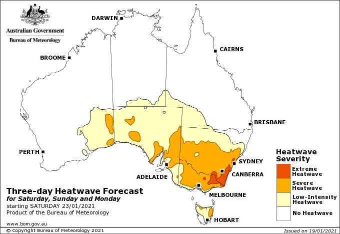
The heatwave situation for Saturday, Sunday and Monday. Image: BOM.
The Bureau of Meteorology has also issued a heatwave alert and may issue official warnings closer to the weekend.
The Bureau’s duty forecaster for NSW and the ACT, Melody Sturm, said the entire ACT and south-east NSW region will see temperatures 10 to 15 degrees above the average of 28 degrees for this time of year.
A heatwave is classified after three days of temperatures above the average, and will become severe to extreme on Saturday, Sunday and Monday.
Night-time temperatures will also be above average and are unlikely to fall below 20 degrees.
“We will be seeing the severe heatwave conditions in the ACT from Saturday onwards, but the heatwave will be more extreme to the south of the ACT in the Monaro and south-eastern areas, including along the coast,” Ms Sturm said.
She added that there will be little relief for Canberrans thinking they can escape the heat by heading to the coast.
“Bega, Batemans Bay and Cooma can expect to see temperatures 11 to 13 degrees above average, with almost no relief from the sea breezes that usually make it a little cooler on the coast.
“The whole ACT and south-east NSW area will hold large amounts of heat for a few days, so we also expect the fire danger to increase significantly as well.”
Bega will likely hit 42°C on Monday, while Batemans Bay is expected to reach 39.
Large parts of the NSW coastline continue to be subject to hazardous surf warnings, including the Illawarra, Batemans Bay and Eden coastlines.
People should consider staying out of the water and should avoid walking near surf-exposed areas. Rock fishers should avoid coastal rock platforms exposed to the ocean and seek a safe location that is sheltered from the surf.
The hazardous surf warning is expected to abate, so the ocean will at least provide some cool comfort, albeit before a dash across the scorching sand.
The heatwave’s main driver is a high-pressure system east of Tasmania which extends a ridge across southern and eastern New South Wales. The high-pressure system will slowly migrate to the Tasman Sea on Thursday where it will remain slow-moving, while a trough extending from a tropical low-pressure system that could become a cyclone in north-western Australia will strengthen over the inland.
This pattern will draw a hot air mass across western and southern New South Wales at the end of the week and over the weekend, leading to heatwave conditions.
There may also be some rain activity later next week associated with the tropical weather system in Western Australia.
Meanwhile, the 2020–21 La Niña is likely to have reached its peak in the eastern and central Pacific Ocean. However, impacts associated with La Niña, such as above-average rainfall in eastern and northern Australia, are expected to persist into early autumn, with climate outlooks indicating above-average rainfall is likely across much of the country, particularly in eastern Queensland.
Original Article published by Michael Weaver on The RiotACT.