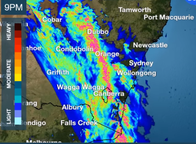
A large band of heavy rain is due to hit the ACT region this evening. Photo: BOM.
The ACT and surrounding region could see as much as 50 mm of rain in two hours later today or this evening as a large band of rain with embedded thunderstorms passes through.
Showers and thunderstorms will develop across central inland NSW, before extending into south-east NSW, the ACT and eastern Victoria.
Bureau of Meteorology forecaster Stephen Stefanac said the first showers could begin from about 5:00 pm before heavier falls become severe with the possibility of flash flooding.
“The heaviest falls are likely between 8:00 pm and 11:00 pm as a large band of storms and rain makes it way through,” Mr Stefanac said.
“Heavy rainfall is the main risk, but there is the potential for some flash flooding and thunderstorms.
“We should see about 20 mm fall but there could be as much as 50 mm of rain from the thunderstorms.”
Mr Stefanac said it was very likely the Bureau would issue severe weather warnings and people are encouraged to check the BOM website or app for updates.
The rain band is expected to pass through the region by midnight when conditions will ease.
https://www.facebook.com/bureauofmeteorology/videos/3462350903887483/
The ACT Emergency Services Agency also issued a warning for people to take precautions early to prevent damage to their homes.
This includes cleaning gutters, moving cars undercover and away from trees, securing or putting away loose items around your house and yard.
The ESA also says people should keep clear of creeks and storm drains and never drive, ride or walk through floodwater.
For assistance in a storm or flood call the ACTSES on 132 500, or in a life-threatening emergency call Triple Zero (000).
The Bureau also said humidity and instability will increase later in the week from Thursday and into the weekend.
Widespread severe weather is expected to impact SA, Victoria, Tasmania, NSW and the ACT, with gales, rain and severe thunderstorms. Temperatures are also set to plummet by 4 to 10°C below average.
Original Article published by Michael Weaver on The RiotACT.


