Cooler conditions during summer have led to lots of green grass. Photo: File.
Canberra has had its coolest summer since 2011-12, and if you are hoping for some heat you’ll be disappointed as the milder-than-usual temperatures are set to continue into autumn, with the Bureau of Meteorology’s Autumn Climate Outlook forecasting more mild conditions in the Canberra region.
It will come as news to no one that the summer of 2020-21 was one of the wettest and coolest in Australia, marked by above-average rainfall and temperatures well below the previous summer’s extremes.
In Australia, the 2020-21 summer was the wettest since 2016-17, with below-average rainfall only in greater south-eastern Queensland from the New South Wales border to the Capricornia region.
December 2020 was the third wettest December since national records began in 1900, while Australian summer temperatures are on track to be the lowest since 2011-2012, with temperatures above average only for parts of Queensland and the west coast of Western Australia.
In the ACT and surrounding region, temperatures were near to or below average, while rainfall was near to above average for all three months of summer.
In Canberra, the warmest day was 38.0°C on 25 January, and the coolest day was on 28 January when the temperature reached 17.9°C.
The coldest morning was 3.9°C on 8 December, and the warmest morning was on 6 February when the minimum temperature was 18.8°C.
There were regular thunderstorms that led to localised flash flooding. The most widespread storms were on the evening of 1 February when Tuggeranong received 18 mm of rain in 12 minutes.
There were relatively few hot Canberra days during summer. There were just three days of 35°C or above, all in January, compared with 19 in 2019–20 and 22 in 2018–19.
The Autumn Climate Outlook shows warmer days are likely only in the northern parts of Australia, Tasmania and the west coast of Western Australia. However, parts of New South Wales may have cooler than average autumn days.
Autumn nights are likely to be warmer than average across large parts of the country.

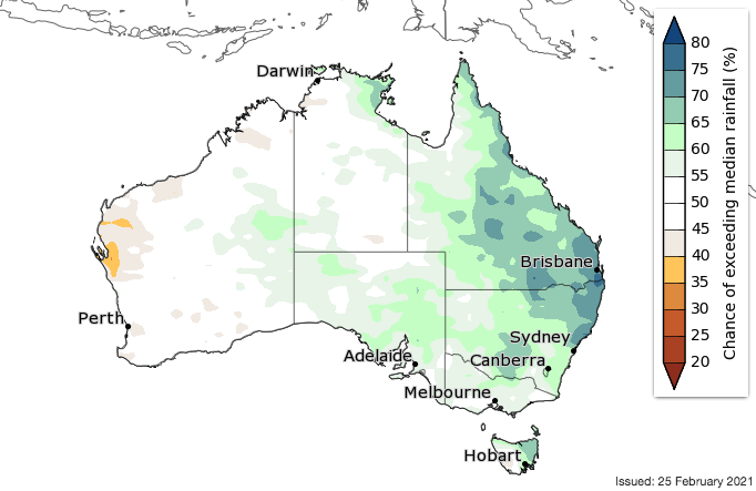
The BOM’s forecast for above-average rainfall for autumn. Image: Bureau of Meteorology.
The Bureau’s climatologist Dr Naomi Benger said while current observations and forecasts show La Niña has passed its peak, its effects on the Australian climate are likely to persist.
“The tropical Pacific Ocean is forecast to return to neutral conditions (neither El Niño nor La Niña) during autumn, consistent with the typical lifecycle of La Niña events,” Dr Benger said.
“However, it is not uncommon for the effects of La Niña to still be felt as the event declines. That means an increased chance of above-average rainfall, particularly for eastern regions.”
High and near-median stream flows are likely until April for most locations in eastern and northern Australia, with a risk of widespread flooding in northern Australia, where soil moisture levels are comparatively high.
The severe weather season, from November to April, has so far seen four tropical cyclones in the Australian region, with one (ex-Tropical Cyclone Imogen) making landfall in the Queensland Gulf Country.
There have also been several significant tropical lows that brought heavy rain and some flooding to parts of northern Australia.
Original Article published by Michael Weaver on The RiotACT.


